

Many articles about the Eastern Trail are organized on this news archives page. The most recent articles appear immediately below, with the first part of each article displayed. Click on any article title, or the “Read More..” link to read the full text of that article.
Group’s goal is to extend trail south from Kennebunk to Kittery
The Kennebunk Post – By Alex Acquisto,Staff Writer
The Eastern Trail Alliance and Southern Eastern Trail Alliance have begun to set new plans for expanding into motion.
Optimally, the off-road trail will continue from South Portland through Wells, North and South Berwick and Eliot, all the way down to Kittery. The alliance held an informational meeting Tuesday, March 26 in North Berwick to discuss expansion plans and feel out any opposition.
Formally designed in 1998 to follow the abandoned Eastern Railway, the Eastern Trail was constructed for runners, hikers, bikers and other general outdoor enthusiasts.
Nearly every year since the millennium, new paths have been forged between South Portland and Kennebunk.
“There was some reluctance in southern Maine about the trail — there was skepticism whether the trail would ever get built over the Kennebunk turnpike,” said Deborah Erickson Irons, director of Choose to Be Healthy Coalition and Eastern Trail Alliance trustee.
“People wondered, ‘Will we ever get the benefits of the trail down here?’ To the town’s credit, they have been patient and now they see that the trail is ready in Kennebunk. We’re over the hurdle of putting it over the turnpike,” she said.
“We’re seeking funding to extend the offroad trail from where it is in Kennebunk now, farther south,” said Erickson-Irons. “We wanted to start generating interest in the south, so we formed a small committee to focus on North Berwick and South Berwick.”
Read the full article online here.
Share this article:
Tuesday, March 19, 2013
NORTH BERWICK, Maine — An informational presentation, “The Eastern Trail: A Trail and a Vision” will be held at 7 pm on Tuesday, March 26 at the North Berwick Community Center, 264 Lebanon Road in North Berwick. Anyone interested in learning about the Eastern Trail is invited to attend.
Have you driven I-95 through Kennebunk and seen the beautiful span over the highway that is part of the Eastern Trail? The off-road Eastern Trail currently ends at the Kennebunk Elementary school, but the vision of trail enthusiasts in southern Maine is for the off-road trail to continue through Wells, North Berwick, South Berwick, Eliot, and Kittery.
The Eastern Trail Alliance is the focused effort to vision, build, promote and use the trail. The Alliance includes many supporters from throughout southern Maine, hikers, bikers, X-country skiers, birders, and other outdoor enthusiasts dedicated to creating, enjoying and maintaining the Eastern Trail.
Panel presenters on March 26 will share the history of building the off-road Eastern Trail, future plans for the trail, reasons to support the trail, and answer your questions regarding the project. Presenters will include Eastern Trail Management District President and Arundel Town Planner Tad Redway; Eastern Trail Alliance President and Saco City Planner Bob Hamblen; and Choose To Be Healthy Coalition Director Deborah Erickson-Irons. Coffee, juice and small desserts will be served.
— About the Eastern Trail —
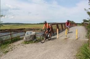
The Eastern Trail is a 65 mile section of the East Coast Greenway, a transportation-recreation greenway connecting South Portland to Kittery. The scenic on-road trail mostly follows quiet country roads. Bike riders, walkers, and hikers can enjoy outdoor experiences from South Portland’s Bug Light Park on Casco Bay (near Portland) to Kittery’s Piscataqua River. In addition to the on-road trail, the Eastern Trail has the growing length of off-road sections.
For more information about the trail and about the meeting, please go to www.easterntrail.org, call The Eastern Trail Alliance office at 207-284-9260, or call Deborah Erickson-Irons at 207-351-2659.
 EASTERN TRAIL INFORMATIONAL MEETING
Included a slide show covering Vision, Successes, and Challenges
And an Eastern Trail Experts Panel:
Eastern Trail Founder, President Emeritus John Andrews
Eastern Trail Alliance President Bob Hamblen, Saco Planner
Eastern Trail Management District President Tad Redway, Arundel Planner
Why was this meeting held in North Berwick, a town that has not supported the ET for ten years? Last year, Kennebunk and Wells asked Maine DOT to fund a final design, ready-to-bid, package for the ET from the end of the off-road section in Kennebunk all the way south as far as their towns allow. That would have meant ending at Perry Oliver Road in Wells. MDOT’s informal response has been that the ET must provide connectivity between major locations. In other words, if the design and construction does not extend all the way to Pratt-Whitney in North Berwick, the project is not fundable.
Some possible outcomes from the meeting:
Click here to read a news article about this meeting (3/19, Foster’s Online). Click here to read another news article about this meeting (Kennebunk Post). Click here to view a video of the meeting.
Click here to view a document that described route options through North Berwick, and includes color maps(this is a large pdf file, it may take some time to download).
The Eastern Trail Management District (ETMD) is a group of representatives from each Eastern Trail town that manages the construction and upkeep of the trail. Below is ETMD’s Spring 2013 newsletter:
Says recreational path helps bring tourists to region
By Molly McPherson news@seacoastonline.com
February 07, 2013 2:00 AM
SOUTH BERWICK, Maine — The Eastern Trail Alliance is hoping to build new off-road trails to replace the current on-road sections of the trail located in town.
Members of the group recently met with the Town Council to discuss the trail improvements. Carole Brush, executive director of the alliance, thanked the town for its continued support of the alliance’s efforts and offered assistance in seeking money to help pay for the design and construction of the new trails.
“South Berwick had been particularly loyal in looking for ways to get the trail funded and built,” Brush said.
The 65-mile Eastern Trail, which is the southern Maine section of the East Coast Greenway trail, connects South Portland to Kittery. However, none of the 22 miles of off-road trails are in southern York County.
“Maine needs new trails,” said Anita Rosencrantz, South Berwick’s representative on the Eastern Trail Management District, a group of volunteers representing towns throughout Maine that abut the trail.
Read the entire article online here
Seacoastonline.com – December 27, 2012 2:00 AM
Last week, the Arundel and Kennebunk Public Works Departments combined forces to install 14 mile markers on over 3.5 miles of the Eastern Trail — extending from the Arundel northern boundary to Route 35 in Kennebunk.
Measuring six inches by 12 inches and mounted at eye level, these double-sided signs are stationed at quarter-mile increments along the off-road sections of the trail and they provide recreationalists with a precise location on the trail. More importantly, geo-coordinates of the mile markers will be recorded in the E911 systems of all fire-rescue and police dispatch centers servicing the Eastern Trail, enabling first responders to identify the precise position of any caller requiring emergency assistance. Recreationalists will also find the mileage markers to be a convenient way of tracking their progress while running, cycling, or walking along the trail. These mile markers were generously donated by Southern Maine Medical Center — a longstanding supporter and a sponsor of many charity and health promoting events conducted on the Eastern Trail.
All distances on the installed signs are measured from the Eastern Trail’s starting point at Bug Light in South Portland Harbor and will terminate at the completed Memorial Bridge in Kittery. The idea of installing emergency mile markers was first broached by the police and fire departments of host communities along the trail. A committee of emergency responders headed by Chief Mike Thurlow of the Scarborough presented the sign design that was adopted by the Eastern Trail Management District for the entire trail.
Read the full article on-line here:
Share this article:
By Deirdre Fleming dfleming@mainetoday.com, Staff Writer. Posted December 1, 2012
 KENNEBUNK – Since the two major bridges connecting the Eastern Trail went in this year, organized events along the trail have increased twofold.
But to a large extent, the fascination, attraction and use of this off-road, woodland trail has been building steam all along.
“The last wintertime moonlit walk we had was last January. That drew 30! We might beat that today,” boomed John Andrews, the 75-year-old retired engineer who is a driving force behind this trail being built between South Portland and Kittery.
Moments later, 40 interested hikers slowly drove up in the dark behind Kennebunk Elementary School to gather around Andrews and naturalist Joe Yuhas at the trail’s kiosk. And after Yuhas, a former University of New England science professor, exclaimed this would be a natural history hike and search for wildlife, the headlamps went off and chatter ceased.
“You don’t have to take a vow of silence, but we’ll move along quietly and see what we see,” Yuhas suggested.
Read the full article online here
Share this story:
By Aislinn Sarnacki, BDN Staff Posted Aug. 29, 2012,at 1:20 p.m.
 Exiting the train in Portland, Philip McGranahan and his wife Marjorie Foote donned helmets, righted their bicycles and headed south on the East Coast Greenway, a route that would lead them along off-road paths and low-traffic roads all the way to Saco.
The Kittery couple pedaled the bike-friendly path several years ago — they couldn’t agree on exactly how many — but as they followed the ECG signs, they noticed that much of the route has changed. In Scarborough Marsh, where a pedestrian bridge opened to the ECG in 2004, they paused and noted that the marsh hadn’t been a part of their previous trip.
Though they ended their day in Saco, the ECG extends much farther. Through Maine, the route currently extends about 380 miles from the Canadian border in Calais to the southern tip of the state. From there, the route continues to the tip of Florida, threading together 16 states.
“The trail is actually intended to connect the communities of Maine so a traveler can see everything from historic mills in Calais, to dam sites in Lewiston, down to the largest chair down in Eliot, Maine,” said Tony Barrett, member of the Maine East Coast Greenway committee. “And the route goes right by the Paul Bunyan statue in Bangor.”
Much of the off-road sections use existing multiuse trails or have been constructed along old railroad beds.
Sections of the ECG in Maine:
• Eastern Trail: Kittery to South Portland, 68 miles.
• Casco Bay Section: South Portland to Brunswick, 35 miles.
• Coastal Route: Brunswick to Belfast to Bucksport, 125 miles.
• River Route: Brunswick to Bangor to Bucksport, 160 miles.
• Down East Route and Down East Sunrise Trail: Bucksport to Calais, 140 miles.
The East Coast Greenway Alliance, founded by 10 trail advocates in 1991, now has partnerships at the local, state and national levels.
Article continues in full here
Share this article:
 ETA Webmaster Note – NY Magazine’s “Five-Point Weekend Escape Plan” was published on 8/17/2012. Part three, which references the Eastern Trail, is highlighted here. Click here to read the whole article.
By Jen Swetzoff; Published Aug 17, 2012
| Part 1 – Where to Stay | Part 2 – Where to Eat |
Part 3 – What to Do
Hike through the 24-acre Marx Preserve (look for the sign off Route 9, opposite a utilities pump station) and explore an ecosystem that’s relatively rare in southern Maine: salt marshes. Bring binoculars to spot birds like great blue herons and goldeneyes among the pines and hemlocks. For more hiking opportunities, follow the adjoining three-mile Bridle Path (access at 71 Sea Road), which goes inland and toward the sea, or check out the Rachel Carson Wildlife Refuge, home to many species including bald eagles and moose.
Get your sea legs at Goose Rocks Beach, one of the most popular places in town for stand-up paddle boarding. The relatively gentle waves are ideal for beginners and the long stretch of white sand, often rippled with tide pools, is a fine place to relax afterwards. You can book a one-hour private lesson with Aquaholics Surf Shop ($75), but if you prefer more traditional paddling, call up Coastal Maine Kayak (half-day rentals from $35), and they’ll deliver a single or tandem boat to you.
| Bike a tranquil stretch of the 65-mile, ten-foot-wide Eastern Trail, which runs from South Portland to Kittery. The six-mile section between Kennebunk (access at the Kennebunk Elementary School, 177 Alewive Road) and Biddeford opened to the public in 2010, and has since become one of the area’s most popular biking routes because it’s shady and relatively easy. Take a break at the pond on the way back and spot deer and wild turkeys through the conifer trees. |
| Part 4 – Insider’s Tip | Part 5 – An Oddball Day |


